
BARROW OBSERVATORY
Barrow Observatory (BRW) has been maintained by NOAA's Global Monitoring Division (formerly the Climate Monitoring and Diagnostics Laboratory (CMDL) and the Geophysical Monitoring for Climatic Change (GMCC)] since 1973. It is the site of numerous atmospheric observational programs that emphasize how variations in atmospheric composition have an impact on climate through interactions with solar and terrestrial radiation. BRW is located at 71.32N latitude, 156.61W longitude at an elevation of 8 m above mean sea level. It is the northernmost U.S. permanent weather and climate monitoring site.
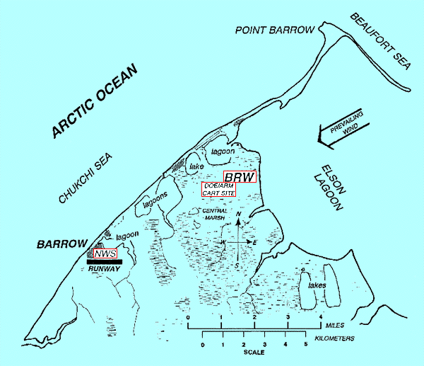
BRW is located so that it receives minimal influence from anthropogenic effects. It is about 8 km northeast of the village of Barrow and has a prevailing east-northeast wind off the Beaufort Sea. It is attended at least 5 days a week for routine inspection and maintenance of the instrumentation.. In addition, the National Weather Service (NWS) maintains a weather observing facility in Barrow. Although the measurements at Barrow are made over open tundra, there are large lagoons and a number of lakes in the vicinity, and the Arctic Ocean is less than 3 km northwest of the site. Because of its proximity to these bodies of water and the fact that the prevailing winds are off the Beaufort Sea, BRW is perhaps best characterized as having an Arctic maritime climate affected by variations of weather and sea ice conditions in the Central Arctic.