More than two years after road access and electrical power to the Mauna Loa Observatory was cut off by lava flows, NOAA staff continue to make critical measurements of the atmosphere and other environmental variables at the remote site.
In 2023, observatory staff installed solar panels at the site and resumed some measurements, including the independent carbon dioxide monitoring programs run by the Global Monitoring Laboratory and Scripps Institution of Oceanography, as well as other atmospheric measurements.
Construction of a temporary road to access the observatory site is anticipated to begin in summer 2025.
Media can contact: Theo Stein (303) 819-7409 (theo.stein@noaa.gov)
Introduction
The Mauna Loa Observatory (Hawaii) operated a Ruby lidar (694-nm wavelength) from December, 1974 to 1998, and has operated a Nd:YAG lidar (532, 1064-nm wavelengths) since April, 1994. The lidars are part of the Network for the Detection of Stratospheric Change (NDSC) and operated by NOAA Earth System Research Laboratory (ESRL).
Lidar (Light Detection and Ranging) measures back scattered light from particles & molecules in meters per steradian and parts per million (ppm). It uses a pulsed laser, telescope and fast detectors and electronics. The Nd: YAG lidar emits light at 532nm and 1064nm. Fast detectors and electronics beneath a telescope measure laser light scattered by atmospheric constituents of multiple wavelengths.
Lidar is used for long term monitoring of the stratospheric aerosol layer. This layer effects solar radiation and ozone. Stratospheric aerosols cool the earth by reflecting light back into space.
Observations
MLO lidars measure aerosol backscatter at multiple wavelengths from the troposphere through the stratospheric aerosol layer. Observations are usually made once per week with more made during campaigns. Temperature is also measured with the Nd:YAG lidar from 30 to 70 km. Weekly observations with Nd:YAG lidars occur at both MLO and Boulder with the aim of conducting accurate, simultaneous ozonesonde and aerosol measurements during the next major volcanic eruption.
The plot above shows the Total Integrated Aerosol Backscatter (IABS) measurements from Mauna Loa since 1980. The eruptions of El Chichon and Mt. Pinatubo are evident. No clear trends are seen in background stratospheric aerosols.
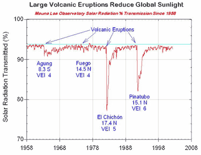
The lidar measures backscatter from volcanic particles and other aerosols high in the atmosphere (15.8-33km). The volcanic particles are composed mainly of water and sulfuric acid and persist for up to a decade following major eruptions such as occurred in 1982 and 1991. These particles influence the ozone layer, and as illustrated in the graph below of apparent solar transmission, reduce the amount of sunlight reaching the earth.
The graph above is from the NOAA ESRL Solar Radiation program.
Lead Investigator(s):
Greg Rose
808-933-6965
Date Started:
Ruby Laser, 1974-1988
Nd:Yag Laser, since 1994
Related Programs:
Camera Lidar
Boulder (CO) Lidar
Samoa Lidar
Trinidad Head (CA) Lidar
General Lidar Info
Lidar Specifications
Station Altitude: 3397m
Latitude: 19.539 N
Longitude: 155.578 W
Time Zone: GMT -10
Laser Type: Nd:YAG
Frequency: Weekly
Acq Board: MCS
# Channels: 4
(nm) used: 532, 1064


