More than two years after road access and electrical power to the Mauna Loa Observatory was cut off by lava flows, NOAA staff continue to make critical measurements of the atmosphere and other environmental variables at the remote site.
In 2023, observatory staff installed solar panels at the site and resumed some measurements, including the independent carbon dioxide monitoring programs run by the Global Monitoring Laboratory and Scripps Institution of Oceanography, as well as other atmospheric measurements.
Construction of a temporary road to access the observatory site is anticipated to begin in summer 2025.
Media can contact: Theo Stein (303) 819-7409 (theo.stein@noaa.gov)
Organization(s):
 University of Hawaii - Manoa,
 Albireo Endeavors,
 Pacific Northwest National Laboratory (PNNL)
What does this program measure?
The MFRSR (Multi-Filter Rotating Shadowband Radiometer) simultaneously measures the total sky, diffuse sky, and direct solar beam intensities at seven wavelengths between 400 and 1050 nanometers. Intensities are converted into irradiances in units of Watts per square meter per nanometer.
How does this program work?
The rotating band is controlled by a dual purpose computer and data logger. Intensities are measured with the band in four different positions: when the band is down the total intensity of the sky is measured; when the band blocks the Sun only the diffuse sky radiation is measured; supplementary measurements are taken with the band adjacent to the Sun to correct for the portion of the diffuse radiation hidden by the band when blocking the Sun. The computer then subtracts the diffuse intensity from the total to obtain the intensity of direct radiation from the Sun.
Why is this research important?
From the irradiance data we extract the optical depths (amounts) of atmospheric aerosols, ozone, and water vapor.
Are there any trends in the data?
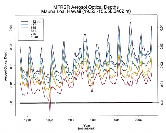
Seasonal trends in aerosol amounts from localized sources are superimposed on longer term trends caused by both naturally occurring aerosol events (dust and smoke plumes, volcanic eruptions) and human-generated aerosols (pollution in general). The case is much the same for ozone.

(Enlarge Plot)
How does this program fit into the big picture?
What is it's role in global climate change?
By monitoring aerosol amounts over time scales of at least a decade the relative influences of naturally occurring and human-generated aerosols on climate can be separated. This will help to answer the question of how people are affecting climate change.
Comments and References
The MFRSR Aerosol Monitoring Network has instruments in Arizona, California, Hawaii, Washington, and Australia.
Lead Investigator(s):
Nels Larson
(email Albireo Endeavors)
530-474-4375
MLO Contact(s):
Paul Fukumura
808-933-6965 (x223)
Web Site(s)
http://www.albireoendeavors.com/
Date Started
1994
