
CO2 Sources and Sinks as Seen by the OCO-2 Satellite: Flux Estimates across 2015-2020 Given by a Dozen Inversion Groups Participating in the OCO-2 V10 MIP
D. Baker
Cooperative Institute for Research in the Atmosphere (CIRA), Colorado State University, Fort Collins, CO 80521; 303-515-9817, E-mail: david.f.baker@colostate.edu
The dense spatial and temporal coverage provided by CO2-sensing satellites such as the Orbiting Carbon Observatory (OCO-2) opens the possibility of estimating regional carbon fluxes for that part of the globe not well-covered by in situ monitoring sites – e.g. the tropics and south. Estimating accurate fluxes in the presence of retrieval biases, on top of the usual errors due to transport and inversion details, is challenging. However, by looking across multiple inversion setups, each using different transport models, meteorological drivers, assumed a priori fluxes and statistics, and inversion methods, and by controlling the data and data uncertainties used, the influence of these different variables may be understood. Over a dozen different inversion groups have participated in a model intercomparison using version 10 of the OCO-2 column CO2 data. Different experiments using subsets of the data (in situ = IS, land nadir + land glint = LNLG, ocean glint = OG) in various conbinations have been performed to help assess relative biases between data types. Comparisons to independent data (upward-looking spectrometers from the TCCON network, aircraft campaign data, AirCore) as well as in situ and OCO-2 data withheld from the inversions, are used to evaluate the results.
Figure 1 shows the impact the OCO-2 LNLG data have on the inversions, in terms of the 6-year average fluxes across 2015-2020 from the model intercomparison project (MIP). Broad agreement down to regional scales is seen across over half the models in the MIP. This agreement suggests that modeling errors will not get in the way of estimating long term carbon sources and sinks from the satellite data: such estimates may be used for emissions treaty verification purposes, for example in the 2023 Global Stocktake.
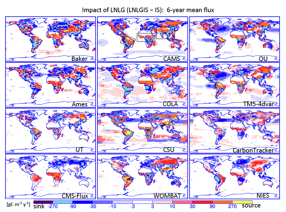
Figure 1. The change in CO2 flux [gC m-2 year-1] from that given by the in situ data that is driven by the use of land nadir + land glint (LNLG) data by twelve different OCO-2 v10 MIP inversion groups, expressed as the difference in 6-year (2015-2020) average flux between the LNLGIS and IS flux inversion experiments. Similar regional patterns are obtained for tropical America, north Africa, and southeastern Asia (see the black boxes in the CAMS panel at top) for the top half of the models.