
Regime-specific Cloud Vertical Overlap Characteristics from Radar and Lidar Observations at the ARM Sites
K. Balmes1, J. Sedlar1,2, L.D. Riihimaki1,2, J.B. Olson1,3, D.D. Turner3 and K. Lantz2
1Cooperative Institute for Research in Environmental Sciences (CIRES), University of Colorado, Boulder, CO 80309; 720-239-2672, E-mail: kelly.balmes@noaa.gov
2NOAA Global Monitoring Laboratory (GML), Boulder, CO 80305
3NOAA Global Systems Laboratory (GSL), Boulder, CO 80305
Non-cloud resolving models require assumptions to represent the vertical distribution of sub-grid scale clouds. The cloud vertical distribution is represented by cloud overlap methods, which have implications for radiative transfer. Vertical profiles of cloud observations from radars and lidars are analyzed to characterize the cloud overlap and assess assumptions employed in models. In this study, ground-based radar and lidar observations at the Atmospheric Radiation Measurement Program (ARM) Southern Great Plains (SGP) site located in Lamont, Oklahoma, United States are utilized to derive cloud overlap characteristics from nearly 25 years of data. The cloud overlap characteristics are further separated by cloud regime by considering seven cloud types (low cloud, congestus, deep convection, altocumulus, altostratus, cirrostratus, and cirrus) as well as periods of shallow cumulus as described in Lim et al. (2019). The cloud overlap characteristics are also separated by seasons. The decorrelation length scale that characterizes the exponential transition of vertically continuous clouds from maximum overlap to random overlap with increasing cloud layer separation is calculated from the cloud overlap observations. Cloud overlap characteristics are also considered for other ARM sites where vertical profiles of clouds are available from the Cloud Type (CLDTYPE) and Active Remote Sensing of Clouds (ARSCL) data products. The additional ARM sites include the Tropical Western Pacific (TWP), North Slope of Alaska (NSA), and Eastern North Atlantic (ENA) sites amongst other shorter term ARM deployments across the globe. The decorrelation length scale is found to vary by site, season, and cloud regime. The results could help inform development of cloud overlap assumptions within operational numerical weather prediction models including the Rapid Refresh Forecast System (RRFS) and Global Forecast System (GFS). Improvement in the characterization of the vertical distribution of clouds could potentially improve prediction of radiative fluxes for weather, climate, and renewable energy forecasting.
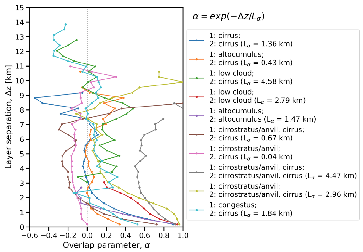
Figure 1. The mean overlap parameter (⍺) binned by layer separation (Δz; km) for vertically continuous clouds at SGP. The observations are separated by cloud types with the most frequent cloud regimes shown. The cloud types for each regime are given for the lower (1) and upper layers (2). The decorrelation length scale (km) for each cloud regime is given in the parentheses.