SOLRAD Network
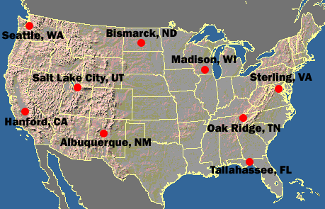
The SOLRAD Network is for monitoring Surface Radiation in the Continental United States, in Collaboration with NOAA's SURFRAD SURFace RADiation Budget Measurement Network.
NOTICE: As of 1 Jan. 2015, SOLRAD network radiation data will be reported at a one-minute frequency.
For background information on the SOLRAD Network, see:
- B. B. Hicks, J. J. DeLuisi, D. R. Matt, (1996), The NOAA Integrated Surface Irradiance Study (ISIS).A New Surface Radiation Monitoring Program Bulletin of the American Meteorological Society Volume 77, Issue 12, December 1996 pp. 2857-2864.
If you would like information about a specific station within the SOLRAD network, please click on its location on the map, or select the link that matches the station name.

| Code | Name | Latitude | Longitude | Elevation |
|---|---|---|---|---|
| ABQ | Albuquerque, New Mexico | 35.03796° N | 106.62211° W | 1617 m |
| BIS | Bismarck, North Dakota | 46.77179° N | 100.75955° W | 503 m |
| HNX | Hanford, California | 36.31357° N | 119.63164° W | 73 m |
| MSN | Madison, Wisconsin | 43.07250° N | 89.41133° W | 271 m |
| ORT | Oak Ridge, Tennessee | 35.96101° N | 84.28838° W | 334 m |
| SLC | Salt Lake City, Utah | 40.77220° N | 111.95495° W | 1288 m |
| SEA | Seattle, Washington | 47.68685° N | 122.25667° W | 20 m |
| STE | Sterling, Virginia Original site (pre Oct 28, 2014) |
38.97203° N 38.97673° N |
77.48690° W 77.48379° W |
85 m |
| TLH | Tallahassee, Florida | 30.39675° N | 84.32955° W | 18 m |
